Less than a week now until I fly off to Valle de Bravo for the fist time to compete in the Monarca Open Paragliding competition. On one hand I am looking forward to it and on the other I am a little anxious still to be flying with over 150 world class pilots and in my new pod harness with no real thermalling hours on it yet. I am sure I will get lots of time to have that in Valle though! Meredyth and Arun have already left and I expect are probably flying as I write this blog entry. I will be traveling down with Gordon Grice and John Mann on January 1st. First comp task is Jan 4th.
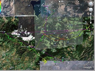
For preparations I have been looking at the Leonardo flights from last years comp on google earth trying to get a handle on the routes folks are taking and figuring out where the thermals are going to be. Of course, in a large gaggle its easy to just follow the leader. At Woodrat this year I had my first experience of flying in a large gaggle and it wasn't as scary as I had thought. You are too busy flying to be worried about anything else. Now I need to start to remember how to use my GPS again.
Since It has been a while since I actively used my GPS to enter routes I have been taking a different approach to getting used to it again. During the summer I had my flight deck on my lap and as I drove to work I hit the Mark key a few times along the way to enter waypoints. On my way back from work I entered the route of the waypoints from my house and then "navigated" back to my house. This simulated what the GPS would do as I neared the waypoints. This month I have been practicing with a little tool called GPS Simulator from FlywithCE. This little free tool from their website allows you to load a .IGC file (Leonardo format) and then send NMEA sentences to the com port of your PC. NMEA is a protocol for transferring GPS information from one device to another. As it happens, my Digifly Cartesio 2 vario allows for external GPS input and I use the Digifly connected to my Garmin GPS as the primary device for flying tasks. This is a great training tool. However, even better I managed this month to discover that Franson GPSGate can also read Nmea log files and then send the output to google earth as well as com ports. So now, I download the tracks from Leonardo of flights taken at Monarca last year and convert to NMEA format using GPS Babel. After downloading the Monarca waypoints and loading these into Google Earth I can see the route taken for tasks.
Now, I just enter the waypoints for that route into my Digifly, Load up the Nmea log file in Franson GPS gate and tell it to send the output to my Digifly and also Google earth at the same time. Voila! Simulated flight of actual tasks visualized in Google earth with my Digifly showing me all the information from that flight in real time. Pretty cool!.
I plan to keep a blog from this years comp and enter some pics/video on a daily basis so stay tuned for updates!
Iain
